Mantle |
A Customized Terrain Pipeline for Simulation and Training |
Effective. Proven. Easy-to-use. Scalable. Cost-efficient. Constantly enhanced. |
Terrain ChallengesMaking terrain for high fidelity simulation is difficult and challenging. Searching out good source data, building correlated terrain for multiple runtimes, synchronizing data between different simulation clients, storing the vast amount of source data, utilizing classified and other restricted data, editing data “on the fly”. Historically, these challenges have resulted in separate specialist teams building terrain data disconnected from the point-of-need users together with high costs and long lead times to obtain the required finished terrain. Mantle solves these challenges. |
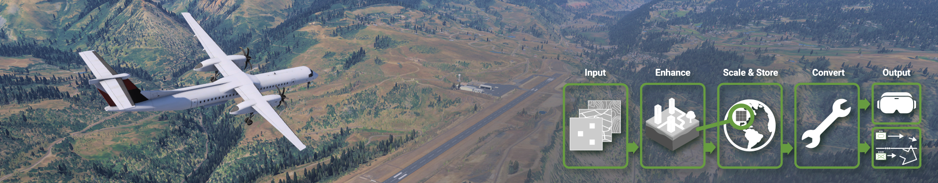
What is Mantle?Mantle Enterprise Terrain Management is a custom-built platform based on proven COTS components and expert design/development services for creating simulated terrain for training, mission rehearsal, visualization and terrain analysis. A Mantle installation delivers a cloud-capable1 custom terrain pipeline that works with your data, processes, servers, and runtimes, integrating with your existing terrain capabilities or delivering a full end-to-end solution from scratch.
1 Cloud is not required, Mantle can also run on an internal network |
Effective: Mantle simplifies enterprise-wide terrain handling for simulation and visualization by providing you a cloud-capable terrain server that can be integrated with your existing terrain capabilities.
Proven: The Mantle platform is based on robust COTS components - TerraTools components (for terrain generation), VBS4’s Blue Data Pipeline technology (for procedural enhancement) and VBS World Server components (terrain storage and server capabilities).
Easy-to-Use: Mantle is designed with accessibility in mind. Users can quickly learn to rapidly create and edit terrain on the fly with the VBS Geo editing tool, leveraging the 8,000+ 3D model content library. Edits can be stored and curated centrally.
Scalable: Mantle can be deployed on the cloud or on a local network, and supports synchronization between servers.
Cost-Efficient: Mantle reduces the manpower needed to develop and deploy terrain by offering a high degree of automation at every stage.
Constantly Enhanced: Mantle components are enhanced regularly with new customer-driven requirements and significant internal investment driving feature improvements such as the curated global base data and extended support for new runtimes and streaming terrain formats.
Proven Capability
The technology that underpins Mantle is already in use with multiple premier military organizations, including the U.S. Army. Several enterprise-wide Mantle deployments are already underway.
Example Integration: LuxCarta BrightEarth
The Mantle platform is incredibly flexible, supporting georeferenced terrain data inputs from almost any source. BISimTM recently demonstrated the integration between Mantle and BrightEarth. BrightEarth provided an API for imagery and feature extraction data (e.g. building and tree locations) and Mantle was integrated to process this data and live-load it into VBS4. This Mantle configuration could, for example, be used to provide high fidelity, procedurally improved base globe to multiple simulations or visualization runtimes.
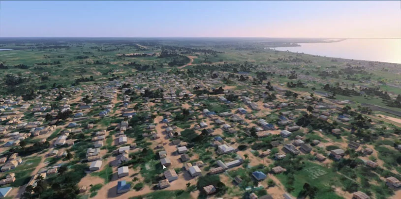
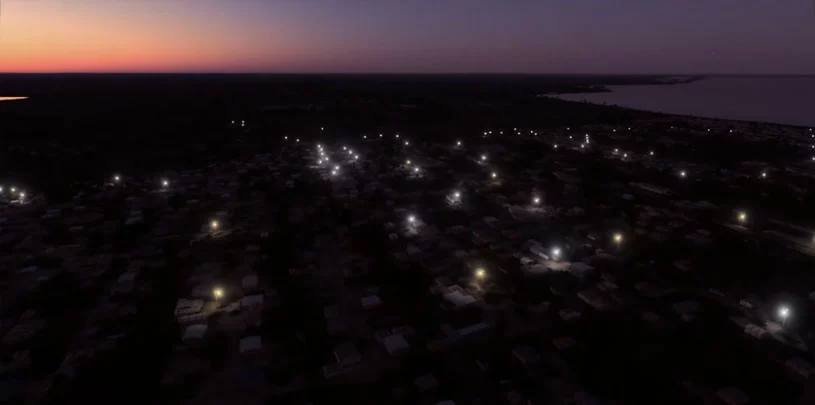
3D environment generated by Mantle, using data from BrightEarth. Day and night scenes shown.
BISimTM offers a support package that entitles license holders to upgrades, essential support services and access to BISim’s customer portal. We also offer professional services hours to help customers develop cost-effective solutions to meet their unique requirements.